![]()
|
|
|
|
|
|

|
"Arfff... " |
Pico da Bandeira (Peak of the Flag), with 2989 meters, is located in Parque Nacional do Caparaˇ (the National Park of Caparaˇ), in Caparaˇ Velho (Old Caparaˇ), MG. The trail to the ascent of the peak is relatively easy with an unevenness of 900 meters, for about of the 5 km. It is usually taken to go up it in 1:50 minutes to 4 and a half hours depending on the physical preparation of the visitor.
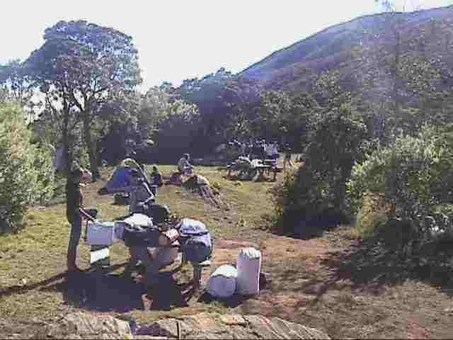
Nowadays, the passage between the entrance of the park and Tronqueira is made by jeeps or cars, and the last place to camp is Tronqueira, where a parking area is situated, and where exists a hand-gliding runway. TerreirŃo is an old stone house that served as a shelter. Formerly, in the summit of the park, there were TV antennas and a shelter that was destroyed by the own users.
|
"Camping in Tronqueira." |
Cachoeira Bonita (Beautiful waterfall) - (1.750 m of altitude) it is the largest waterfall of the park with 80 m of fall. The best time to watch it is the one of the rains (autumn and summer), when the waterflow becomes more intense.
TerreirŃo - it is an old camp, that is in renovation(july/1998). It is currently interdicted for camping. It is situated in a small plain, close to several peaks and moountains. The temperature there falls the 0o C by nights. It is the last place you will see water, in the ascent for the picks.
Tronqueira - it is the main camp of the park, with good camping infrastructure and parking area. It is also the most distant point you can reach with a car. The temperature in Tronqueira is very low, reaching, at night, 5o C. There is drinking water in Tronqueira,
Pico do Cristal (Crystal Peak) - it is placed in the National Park of Caparaˇ, in the Mountain of Caparaˇ, in the state of Minas Gerais (MG), close to the Pico da bandeira. It is the fifth higher pick of Brazil with 2.780,0 m. The crystalline formations of quartz gave origin to its name.
Vale Encatado (Charmed Valley) - it is placed in JosÚ Pedro river's valley, 1.980 m of altitude, above the Beautiful Waterfall. There are many natural swimming pools and waterfalls.
Peak of the Flag - it is located in the National Park of Caparaˇ, in the Mountain of Caparaˇ, in the boundary of EspÝrito Santo (ES) and of Minas Gerais (MG) states. The denomination of the peak is because D. Pedro II who, in 1859, ordered to hoist a flag there. It is the third higher pick of Brazil with 2889,8 m. Until the middles 1960's, when the measurements of Pico da Neblina (Peak of the fog) (3.014 m) and 31 de Maršo (march, the 31st) (2.992 m), Peak of the Flag was considered the highest peak of the country.
|
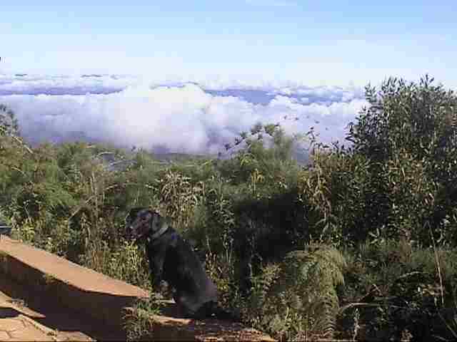
"Great view! " |
The access walk to the Peak of the Flag, for the trail of the Alto Caparaˇ Entrance, can be made in 4 (four) stages:
First stage: from the city of Alto Caparaˇ (High Caparaˇ) to the Alto Caparaˇ Entrance of the National Park of Caparaˇ (2 km). That dirt road course can be made by own car or rented.
Second stage: from the Entrance Alto Caparaˇ (entrance of the park) to Tronqueira (6 km) This partially paved highway course can be done by own car or rented. Observe the nature. Visit Vale Verde (Green Valley) - that is formed by the river Caparaˇ -, with natural pools and infrastructure for picnics. In Tronqueira, where you can camp, see the Beautiful Waterfall (80 m of fall), the Charmed Valley and the observatory deck.
Third stage: from Tronqueira to TerreirŃo (4,5 km). This well outlined trail accompanies JosÚ Preto river's valley. It can only be done on foot, or mounted in mules, that can be rented. In TerreirŃo, where one can camp, take a look at the Casa de Pedra (Stone House) and the Peaks of the Crystal and of the Shoe (Pico do Calšado)
Forth stage: from TerreirŃo to the Peak of the Flag (4,5 km). This trail course is not well demarcated. It accompanies the slopes of the mountain and it can only be done on foot. A part of it (2 km) can be done riding mules, that can be rented.
How to Arrive:
From Belo Horizonte - The National Park of Caparaˇ is 330 km from Belo Horizonte (MG). The access from Belo Horizonte (MG) to Alto Caparaˇ (MG) is done integrally in asphalted highways. Leave Belo Horizonte (MG), by the highway BR-262, towards Vitˇria (ES), until the city of Manhuašu (MG) (280 km from Belo Horizonte). After the entrance of Manhuašu (MG), in BR-262, take, to the right, the highway for Manhumirim (MG) and Presidente Soares (MG). In Presidente Soares (MG), take, to the left, the highway for Alto Caparaˇ (MG).
From Rio de Janeiro - The National Park of Caparaˇ is 430 km from Rio de Janeiro (RJ). The access from Rio de Janeiro (RJ) to High Caparaˇ (MG) is done integrally in asphalted highways. Leave Rio de Janeiro (RJ), by the highway BR-040, towards Belo Horizonte (MG), until the city of Trŕs Rios (RJ) (123 km from Rio de Janeiro). Take, to the right, the highway BR-116, towards Salvador (BA), until the city of Fervedouro (MG). In Fervedouro (MG), take, to the right, the highway for Carangola (MG). In Carangola (MG), take, to the left, the highway for Presidente Soares (MG). In Presidente Soares (MG), take, to the right, the highway for Alto Caparaˇ (MG).
From SŃo Paulo - The National Park of Caparaˇ is 910 km from SŃo Paulo (SP). The access from SŃo Paulo (SP) to Alto Caparaˇ (MG) is done integrally in asphalted highways. Leave SŃo Paulo (SP), by the highway BR-381, until Belo Horizonte (MG) (586 km from SŃo Paulo). Take, to the right, the highway BR-262, towards Vitˇria (ES), until the city of Manhuašu (MG) (280 km from Belo Horizonte). After the entrance of Manhuašu (MG), in BR-262, take, to the right, the highway for Manhumirim (MG) and Presidente Soares (MG). In Presidente Soares (MG), take, to the left, the highway to Alto Caparaˇ (MG).
From Vitˇria - The National Park of Caparaˇ is 255 km from Vitˇria (ES). The access from Vitˇria (ES) to Alto Caparaˇ (MG) is done integrally in asphalted highways. Leave Vitˇria (ES), byr the highway BR-262, towards Belo Horizonte (MG). 15 km after the boundary of EspÝrito Sainto and of Minas Gerais states, in BR-262, take, to the left, the highway to Manhumirim (MG) and Presidente Soares (MG). In Presidente Soares (MG), take, to the left, the highway to Alto Caparaˇ (MG).
|
Tips by GUSTAVO VIVACQUA |
|
1. The visit cost R$ 3,00 and the camp or permanence (it is allowed), R$ 6,00. 2. The better time of the year to visit the park is in the winter. The clear and cloudless days and the cold climate contribute to the walk. 3. From the entrance of the park to Tronqueira (6 km of highway in renovation), you can do with your own car or a rented jeep (rented in the city). 4. You can camp in Tronqueira, where there is a good infrastructure. 5. Don't miss visiting Cachoeira Bonita (Beautiful Waterfall). 6. The trail from Tronqueira to the Peak of the Flag is steep (1000 m), long (9 km) and tiresome (approximately 4 hours of walk). Carry the strictly necessary. 7. Climb it in two stages: Tronqueira (1.970 m of altitude) - TerreirŃo (2.450 m of altitude); TerreirŃo (2.400 m) - Peak (2.890 m of altitude). 8. If possible, go up the trail of the Peak of the Flag at night, leaving Tronqueira about 0:00 h. This way, you'll reach the peak about 5:30am, from where one can witness the sunrise. That's an unforgettable show! 9. Only do the longest trails (mainly the one of the Peak of the Flag) with an experienced guide. The trails are relatively easy, but for the unexperienced mountaineer it can become tricky, mainly after TerreirŃo. 10. There is no electric power nor snack bars inside of the park. Therefore, take the whole equipment that is needed, like flashlights, lanterns, stoves and food. 11. There are several waterfalls in the outskirts of the park. 12. Near Tronqueira you can also visit Beautiful Waterfall and Charmed Valley. 13. "A little after the entrance of the park is the Green Valley, where the visitor can find barbecue grills, bathrooms and waterfall. Remember: don't leave dirt in the park nor make pee inside of the waterfalls. The nature thanks." tip from Maximiliano Marques 14."Going in July, you can enjoy the Ecobike caparaˇ. It is 4 days of trails that surround the park with technical and medical support." Tip from Ligia - Vitˇria (ES) |
CLICK HERE to send your tip
CLICK HERE TO SEE OTHER BRAZILIAN DESTINATIONS
![]()